Earth & energy systems / DEMETER
DEMETER: transferring physical context into farm telemetry
DEMETER organizes agricultural observations around practical state questions: water availability, nutrient demand, equipment recovery, and progress through the growing season. Its specification makes the source of each parameter part of the design.
Research settingNASA
TL;DR
In brief
The question
Can farm sensor, satellite, weather and soil data be interpreted using published physical constants alone, without fitting parameters to each farm, and still hold across sites?
What the work does
A v2.0 specification: a per-field daily data model joining public soil, weather, satellite and equipment feeds; one resource ratio instantiated for moisture, nutrients, equipment, phenology and markets; and worked examples.
What is still open
The specification’s own protocol, about 100 fields scored against NASS county yields from public data, is the next test; reported examples are small and partly simulated.
Available recordVersion 2.0 technical specification; the absence of local fitting is a design choice, not evidence of universal transfer.
From the research record
Inspect the work
Original figures, recorded values, and explicit model details. Each exhibit identifies its source and what the comparison means.
The fields the model actually keeps
Scroll horizontally to inspect the full table →
| Bundle / key | Retained quantities | Units or context |
|---|---|---|
| field_observations / field_id + date | tau_m, K_m, sm, precip, et0, kc | days; in/day; moisture %; in; in/day; crop coefficient |
| equipment_telemetry / machine_id + timestamp | tau_e, K_e, hydraulic_psi, engine_rpm | ms; ms; psi; rpm |
| fields / field_id | soil_series, awc, om_pct, root_depth | Soil series, water capacity, organic matter %, rooting context |
| phenology_tracking / field_id + date | gdd_accumulated, gdd_remaining, growth_stage | Growing-degree-days and labeled growth stage |
| market_observations / commodity + report_date | ending_stocks, consumption, tau_mkt | Million bushels; million bushels/month; months |
Transcribed from the specified GIGI bundles. This is a data model, not a table of farm observations. The domain-dependent units are retained; equal formula shapes do not make moisture, machinery and markets equivalent.
DEMETER-SPEC.md · Version 2.0, section 1.4 Data Model
The research in context
A modern farm produces many streams of data: soil-moisture probes, satellite vegetation indices, weather-station records, and telemetry from tractors and combines. Turning them into decisions — when to irrigate, whether nitrogen is running short, whether a machine is degrading — requires reading each value against the conditions that give it meaning. The same moisture percentage can be ample in a deep silty clay loam and scarce in a shallow sandy soil. Many commercial tools learn these relations from each operation’s own records, which needs long local histories. A physically grounded approach starts instead from published soil and crop properties, but must show those properties carry over to individual fields.
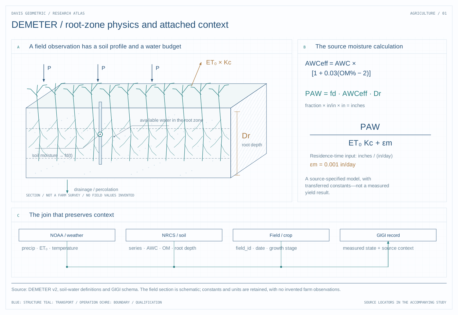
DEMETER’s v2.0 specification draws on free public sources: the NRCS Web Soil Survey for available water capacity, organic matter and drainage; NOAA ASOS weather via the Iowa Environmental Mesonet, from which FAO-56 Penman–Monteith reference evapotranspiration is computed; Sentinel-2 and Landsat imagery for vegetation indices; USDA crop-layer, yield and supply reports; and, with farmer authorization, John Deere Operations Center equipment data. Each domain uses the ratio C = τ/(K + ε_d), with τ a residence time and K a demand rate. For moisture, τ is plant-available water divided by crop water demand, itself reference evapotranspiration times a published crop coefficient. The stack is a Rust backend over the GIGI database with a React front end.
The specification works one case through with published values. For three central Illinois soil series — Flanagan, Drummer and Catlin — it combines NRCS water-holding capacity and root depth with a July reference evapotranspiration of 0.22 inches per day and a mid-season corn coefficient of 1.20, giving moisture residence times of roughly 29 to 35 days. These are structural upper bounds that assume a full soil profile at field capacity; operational values would be lower. The calculation shows that every input is traceable to a named source, not that predictions transfer between farms.
A daily observation is more than a sensor value
The specified data model attaches weather, crop, soil, and field context to each observation. Soil available-water capacity, crop coefficients, precipitation, reference evapotranspiration, and growing-degree-day accumulation appear alongside the field and date. Equipment telemetry has its own machine identifiers and recovery-time quantities.
This is the representational contribution: a moisture reading is interpreted with the substrate and demand that give it meaning. A single number pooled across soils or growth stages would erase distinctions that the model needs.
Three classes of constants
The specification separates structural regularization constants, transferred physical constants, and farm-specific fitted parameters. It proposes using the first two without estimating the third at deployment. That is more precise than saying the system has no parameters.
Transferred constants still have units, source populations, and validity ranges. The specification’s ratios use domain-dependent quantities, so the repeated form C = τ/(K + εd) cannot by itself make a moisture calculation equivalent to an equipment or market calculation. Each interpretation needs a dimensional and empirical bridge.
The next research step
A useful field study would compare predicted state changes with held-out farms and seasons while tracing errors back to the transferred constants. That would test the claimed portability rather than merely checking that the formula runs.
Background mathematics and definitions
Organize the analysis around a declared balance law and its measured and unmeasured terms. Record units, depth or spatial support, sensor calibration, and the provenance of transferred coefficients. Missing observations are not interchangeable with zero flux.
- Storage
- Water in the specified soil volume and time interval.
- Transferred parameter
- A coefficient obtained elsewhere and applied under stated assumptions.
- Balance error
- Unaccounted terms, measurement error, or model discrepancy.
Illustrative example
An illustrative balance with 10 units of input and 7 units of output implies a 3-unit storage increase only if the boundary and other terms are correctly specified. An unmeasured drainage term changes that inference without changing either reported sensor value.
This background example is separate from the source records and the main technical figure.
Source record
Additional source versions reviewed
-
demeter/DEMETER-SPEC.mdLocal project manuscript or report · not republished here
No new experiments are reported in this research note. Figure captions distinguish saved research records, source-model calculations, and explanatory diagrams.